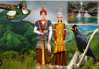
The Sanskrit word "Meghalaya" means the Adobe of Cloud. The word was adopted for naming the state, as the areas were proverbially associated with clouds and rains. GPS location of Meghalaya is Longitude=25° 29' 14.6004'' N and Latitude=90° 24' 45.8460'' E.
i. The Meghalaya is known as Scotland of the East.
ii. Major languages - Khasi, Garos, Pnar , English.
iii. State capital - Shillong.
iv. Total geographical area is 22,429 sq. km.
v. Total population- 29,66,889 (as per Census 2011)
vi. Literacy rate: 75.48
vii. Total District is 12
viii. State Bird: Hill Myna
ix. State Animal: Clouded Leopard
x. State Flower: Lady Slipper Orchid
xi. Major Minerals: Coal, Limestone etc.
National Park in Meghalaya
🌲 Balpakram National Park
This is a mysterious place of Meghalaya. Its Located in South Garo Hills. The literal meaning of Balpakram is the “land of perpetual winds”. Balpakram has many mysterious and unnatural phenomena. Balpakram is so steeped in myths that even the Hindus believe that it is a sacred place. They believe that when Laxman was seriously injured in the war, a very rare lifesaving herb was required, Lord Hanuman found it here but not knowing which to take, broke the top of the hill and carried it away. The missing portion of that hill became a deep awning canyon.
The National Park is home to Elephants, Tigers, Sambar, Barking deer, Gaur, Clouded leopard, Red panda, Black bear.
🌲 Nokrek National Park
Norkek National Park is Spread in East Garo Hills and West Garo Hills. UNESCO added Nokrek National park to its list of Biosphere Reserves in May 2009. Nokrek Biosphere Reserve covers an area of 820 Sq.Kms. This National park is home to Indian Elephant, Hoolock Gibbons, Capped Langur, Stump Tailed Macaque, Clouded Leopard, Leopard, Gaur, Sambar, Barking Deer, Himalayan Black Bear, Sloth Bear.
Tourist Places:
Umiam (Barapani)
 |
| Source Google |
Shillong
Shillong is a hill station in the State of Meghalaya, also it is Capital of the State. Shillong called the Scotland of the East because the rolling hills around the town reminded the British of Scotland. It also known as "The Land of Sevenhuts". The 1960 meter high Shillog Peak, 10 km from the city is another fantastic tourist spot.
Cherrapunjee
 |
| Source Google |
Cherrapunji or Sohra is a sub-divisional town East Khasi Hills district of Meghalaya. It was the traditional capital of ka hima Sohra (Khasi tribal kingdom). Sohra or “Cherrapunji” is said to mean “land of oranges.” It is 1300 meters above of sea level. Cherrapunji itself receives a staggering 11,777 mm of rainfall annually. The Mawkdok Dympep Valley View is a picturesque viewpoint in Cherrapunji.
Mawsynram
 |
| Source Google |
It is a town in the East Khasi Hills district of Meghalaya, 69 kilometres from Shillong, the state capital. Mawsynram receives the highest rainfall in India. It is reportedly the wettest place on Earth, with an average annual rainfall of 11,872 millimetres.
Dawki
 |
| Source Google |
It is border township along Indo-Bangladesh border. It stands by side of Umngot river.
Nongriat
Nongriat’s double-decker root bridge is unique because of its multi-level formation. It took years for these beautiful examples of botanical architecture to develop.


